I previously reported on the imminent testing of the city’s siren system; Washtenaw County will resume testing its siren system (which is independent of the city’s system) this month as well.
The county’s sirens are tested at noon on the first Saturday of every month from March through October. This means the first test will be at noon this Saturday, March 7.
Except for scheduled tests, the county’s sirens will be activated when:
The National Weather Service has issued a tornado warning
A severe thunderstorm has been detected with damaging winds in excess of 70 MPH
A hazardous materials accident requires immediate protective action by the public
An attack on the United States is imminent, underway or has recently occurred
NWS Detroit has issued a severe thunderstorm warning for most of Washtenaw County until 5:45pm. This warning is in the path of a storm which developed south of Jackson and is tracking northeast at 28 mph. Hazards from this storm include 60mph wind gusts and quarter-sized hail.
The storm is expected to be near Barton Hills/Ann Arbor at 5:20pm.
I will monitor this storm; as we saw earlier, storms today have been dissipating more quickly owing to the relatively cool temperatures, so this storm may no longer be severe by the times it reaches us.
KDTX Composite Reflectivity 4:26pm July 27 2013
WUUS53 KDTX 272026
SVRDTX
MIC161-272145-
/O.NEW.KDTX.SV.W.0092.130727T2026Z-130727T2145Z/

BULLETIN - IMMEDIATE BROADCAST REQUESTED
SEVERE THUNDERSTORM WARNING
NATIONAL WEATHER SERVICE DETROIT/PONTIAC MI
426 PM EDT SAT JUL 27 2013

THE NATIONAL WEATHER SERVICE IN DETROIT/PONTIAC HAS ISSUED A

* SEVERE THUNDERSTORM WARNING FOR...
  WASHTENAW COUNTY IN SOUTHEAST MICHIGAN...

* UNTIL 545 PM EDT

* AT 421 PM EDT...A SEVERE THUNDERSTORM WAS LOCATED NEAR GRASS
  LAKE...AND MOVING EAST AT 25 MPH.

  HAZARD...QUARTER SIZE HAIL AND 60 MPH WIND GUSTS.

  SOURCE...RADAR INDICATED.

  IMPACT...HAIL DAMAGE TO VEHICLES IS EXPECTED. EXPECT WIND DAMAGE TO
           ROOFS...SIDING AND TREES.

* THE SEVERE THUNDERSTORM WILL BE NEAR...
  MANCHESTER AROUND 440 PM EDT.
  PLEASANT LAKE AND CHELSEA AROUND 450 PM EDT.
  DEXTER AND HUDSON MILLS METROPARK AROUND 505 PM EDT.
  DELHI MILLS AROUND 515 PM EDT.
  BARTON HILLS AND ANN ARBOR AROUND 520 PM EDT.
  DIXBORO AND YPSILANTI AROUND 530 PM EDT.

THE WARNING INCLUDES AREAS SURROUNDING THESE LOCATIONS...
  DIXBORO...            YPSILANTI...          SALEM...
  MANCHESTER...         DEXTER...             CHELSEA...
  ANN ARBOR...

PRECAUTIONARY/PREPAREDNESS ACTIONS...

FOR YOUR PROTECTION MOVE TO AN INTERIOR ROOM ON THE LOWEST FLOOR OF A
BUILDING.

&&

LAT...LON 4243 8396 4243 8355 4225 8355 4207 8413
      4231 8414
TIME...MOT...LOC 2026Z 249DEG 22KT 4219 8417

HAIL...1.00IN
WIND...60MPH

$$
KDTX Vertically Integrated Liquid 4:13pm July 27, 2013
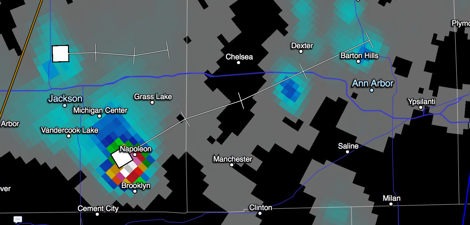
A severe thunderstorm has developed south of Jackson and will hit Ann Arbor around 5:00-5:10pm. The storm is currently producing 40+mph wind gusts and 1/2″ hail. It is south of Grass Lake, over Napoleon, right now.
The storm is severe-warned in Jackson County until 5pm. It may or may not be classified severe by the time it hits Ann Arbor; I don’t know how much it might dissipate before then. But I do expect to see a decent thunderstorm downtown shortly after 5pm.
For those curious, these are the criteria used in SE MI for determining whether extreme heat warrants a heat advisory or an extreme heat warning:
Excessive Heat Watch – Issued when the Heat Index (HI) may be at least 105° within the next 2 to 3 days.
Heat Advisory – Issued when the HI is expected to be at least 100° for 3 hours or more. Can be issued with lower criteria with successive days heat.
Excessive Heat Warning – Issued when the HI is expected to be at least 105° for 3 hours or more. Can be issued with lower criteria with successive days heat.