Thunderstorms likely tonight; slight risk of severe weather

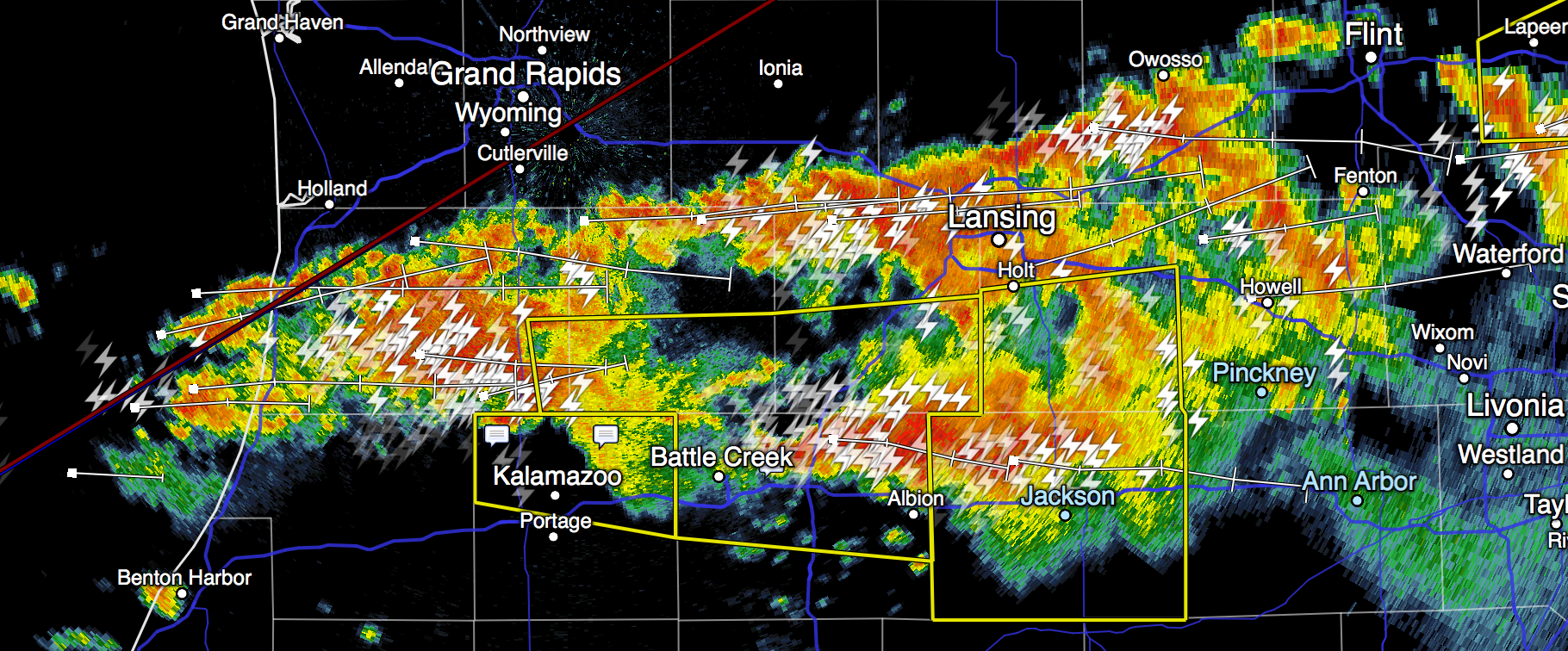
Thunderstorms are likely this evening across southeastern Michigan. There’s a chance some of these storms could become severe, mainly from 10pm-3am.

Any severe storms tonight will be capable of producing damaging wind gusts and large hail. There’s a possibility of tornadoes forming, but that seems relatively unlikely at the moment.

Some storms tonight will come with locally very heavy rainfall, which may produce localized flooding (particularly in areas of town prone to this problem, like Depot Street). Remember, don’t walk through or drive into flooded areas:

A mere 6 inches of fast-moving flood water can knock over an adult. It takes just 12 inches of rushing water to carry away a small car, while 2 feet of rushing water can carry away most vehicles.

In anticipation of this storm, try to get out around your neighborhood and clear out any storm drain blockages you notice. That’ll help your area avoid flooding.

Finally, storms tonight are likely to bring plenty of lightning. Stay safe.

Tune into our local emergency broadcasters for timely updates and alerts tonight, and follow me over at @ArborWX. It might be useful to review what a severe weather watch vs. a warning means:

Tornado Watch: The Storm Prediction Center (SPC) issues Public Tornado Watches to alert the public, media and emergency managers to organized thunderstorms forecast to produce three or more tornadoes or any tornado which could produce EF2 or greater damage.

Severe Thunderstorm Watch: The Storm Prediction Center (SPC) issues Public Severe Thunderstorm Watches to alert the public, media and emergency managers to organized thunderstorms forecast to produce six and more hail events of 1 inch (quarter) diameter or greater, or damaging winds of 50 knots (58 mph) or greater.

Tornado Warning: … are issued when there is radar indication and/or reliable spotter reports of a tornado.

Severe Thunderstorm Warning: … are issued when there is radar indication and/or reliable spotter reports of hail of 1 inch (quarter) diameter or greater, and/or wind gusts of 50 knots (58 mph) or greater.

SPC Thunderstorm Outlook 2016-06-22 8pm-Midnight EDT

Emergency siren tests begin this weekend

It may be hard to believe with this week’s snow, but the spring severe weather season is just around the corner. To prepare, the county’s and city’s regular outdoor warning siren system tests resume this month. Here are their schedules:

Washtenaw County operated sirens will be tested at noon on the first Saturday of every month from March through October. This means that this Saturday, March 5, at noon is the first Washtenaw County siren test of the year.

The City of Ann Arbor’s sirens are tested every second Tuesday of the month at 1:00 pm. Testing of sirens is performed from March through November. This means that this Tuesday, March 8, at 1 pm. is the first City siren test of the year.

If there’s a severe weather threat on the afternoon of a test, the test will be delayed until the following month.

Outside of scheduled tests, these sirens sound in case of:

  • A tornado warning anywhere in Washtenaw County.
  • A severe thunderstorm warning with confirmed winds of 75 miles per hour or greater anywhere in Washtenaw County.
  • A hazardous material spill that requires immediate protective action.
  • Any other local emergency that requires immediate action or for other national threats such as an imminent threat alert from the U.S. Department of Homeland Security – National Terrorism Advisory System.

When you hear these sirens, you should go inside, take cover, and tune in to one of the county’s emergency broadcasters for further information:

  • WEMU 89.1 FM
  • WWWW 102.9 FM
  • WQKL 107.1 FM (City of Ann Arbor only)
  • WTKA 1050 AM (City of Ann Arbor only)
  • WLBY 1290 AM (City of Ann Arbor only)

For the City of Ann Arbor, emergency alerts will also be broadcast on Community Television Network (channels 16, 17, 18 and 19), emailed to “emergency alerts” subscribers, and shared via the city’s Facebook and Twitter pages.

For more information:

Severe weather moving into Ann Arbor shortly

As promised, a cold front moving through the region is bringing with it strong thunderstorms, hail, damaging winds, and tornados.

A powerful line of storms (radar image below) stretches from Jackson west to northwest of Kalamazoo, and the humid air will continue to fuel storm development until 1 or 2 am.

The storm currently over Jackson is currently severe-warned and will continue toward Ann Arbor in the next 30-40 minutes. It appears to be weakening very slightly, but severe activity behind that continues to move east toward us.

It does appear that the furthest-west activity is slightly north of Ann Arbor and if it continues due east, it ought to remain mostly over Livingston County. But it is too early to say that with certainty; there’s plenty of warm, humid air to go around, and it appears that storms are forming along I69 between Coldwater and Marshall; if those continue to develop they’ll certainly hit us.

It is hard to predict with certainty whether any of these storms will be severe when they hit us. But we will see some strong storms in Ann Arbor tonight. Generally speaking, they will come with lots of lightning, some hail, and strong (possibly damaging) winds. Rain will be moderate, heavy, or locally torrential.

Storms ahead of this front have earlier produced strong low-level rotation and possible tornados, and a tornado watch remains in effect until 3am. Where the front north of M59 produced many severe cells and tornado warnings, it does appear the storms headed toward us are less happy to produce strong rotation, but of course this could change and we should remain alert until the tornado watch is cancelled.

Tune to local emergency broadcasters for reliable updates. (Follow ArborWX too, but ArborWX might fall asleep.)

Screen Shot 2015-06-22 at 23.53.56

Significant severe weather expected in SE Michigan this afternoon/evening/tonight

There is a significant chance of severe weather this afternoon into tonight across southeast Michigan. A first wave of storms will occur as a warm front lifts through the region, and a second wave as a corresponding cold front moves through later tonight.

This afternoon and evening, expect strong and potentially severe thunderstorms with heavy rain, damaging wind gusts (up to 60mph), and localized hail up to 1″ in diameter.

Tonight (after 8pm until early morning), expect yet stronger storms with more intense wind gusts (up to 70mph), heavy rain, and localized golf-ball-sized hail. This second wave of storms comes with a tornado risk as well; there is a relatively significant chance for tornados to form in SE Michigan. The risk is greatest north of M-59; NWS reports the risk north of M59 is from 9pm-2am and south of M59 (so, for Ann Arbor) is from 11pm-4am.

Skywarn spotter activation is likely with these storms.

As always, it is not possible to predict ahead of time exactly when a storm will strike Ann Arbor specifically; these predictions are for the larger SE Michigan region at this time.

Tornado watch issued including Ann Arbor until 8pm

Update: as of 5:33pm this tornado watch has been cancelled.

ww0164_radar_big


A tornado watch has been issued for our area, effective immediately until 8pm.

This means that the storms moving into the area this afternoon will provide conditions ideal for the formation of tornados.

You should continue monitoring local media for any severe storm or tornado warnings. (Here’s a list of Washtenaw County’s emergency broadcasters.)

And you should prepare by reviewing these tornado safety tips.