Thunderstorms likely this afternoon/evening; slight severe storm risk (June 25)

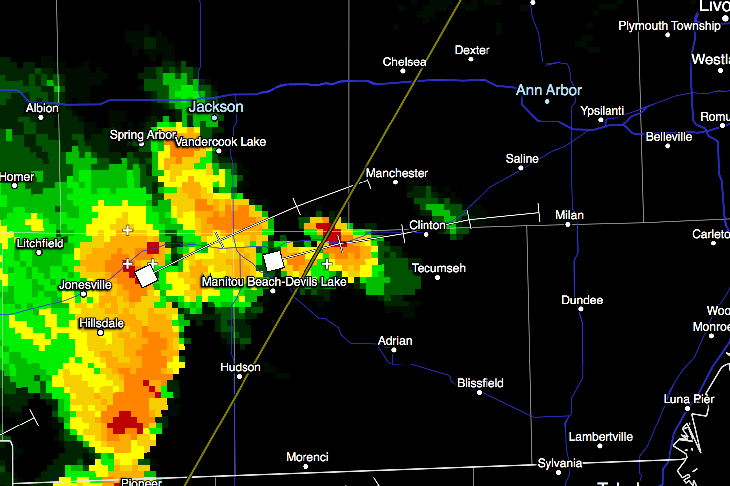
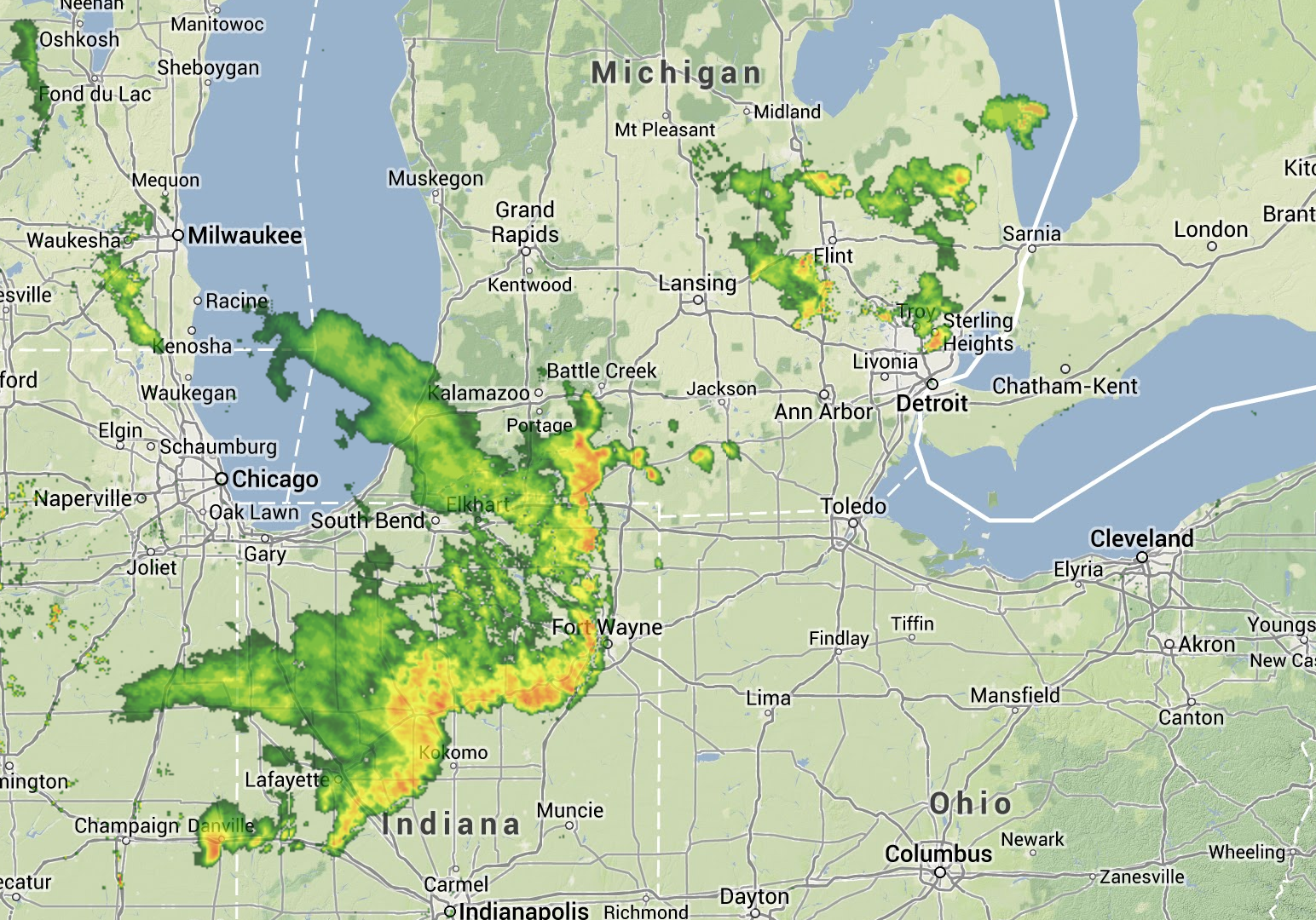
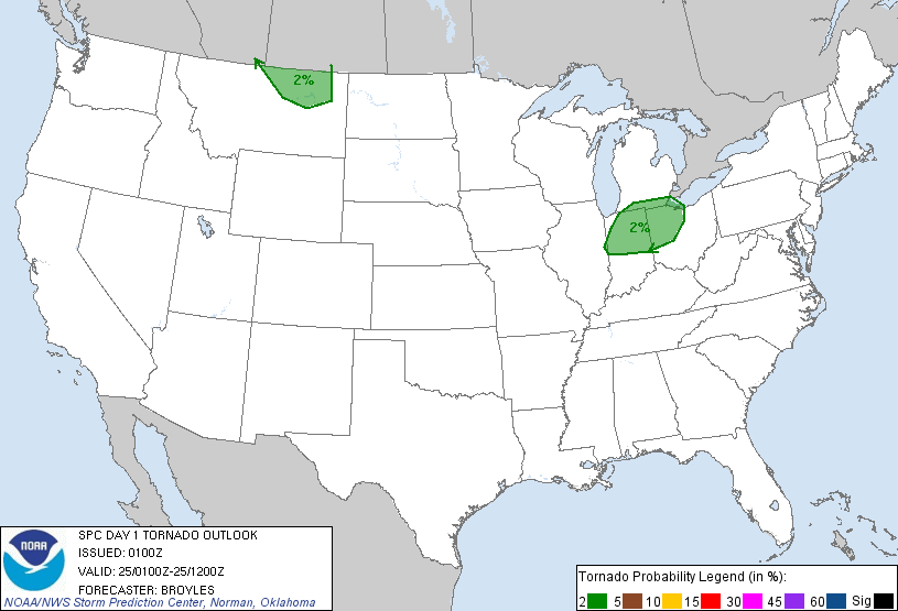
Several rounds of thunderstorms are likely across the area this afternoon into tonight. Heavy rain will be posible with some storms. There is a slight risk that some of these storms will be severe, with the primary threats being damaging winds (60mph gusts possible) and large hail. The best potential for severe storms is this afternoon and early evening. A tornado threat is minimal in our area. I wouldn’t worry about that today; straight-line wind gusts are a much more likely problem.

The relevant portion of today’s hazardous weather outlook:

.DAY ONE...TODAY AND TONIGHT

A MIDLEVEL DISTURBANCE WILL PASS THROUGH THE CENTRAL GREAT LAKES
TODAY AND TONIGHT...MAKING THUNDERSTORMS LIKELY ACROSS THE AREA.
THERE IS A SLIGHT RISK FOR SEVERE WEATHER...WITH DAMAGING WIND
GUSTS TO 60 MPH AND HAIL TO ONE INCH IN DIAMETER POSSIBLE. STORM
MOTION WILL BE WEST TO EAST AT 30 MPH.

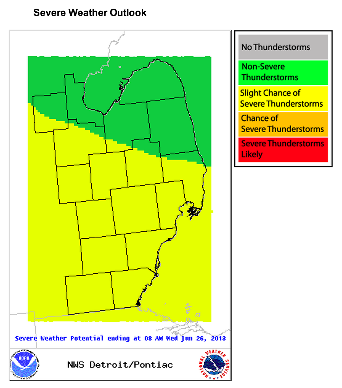
NWS Detroit has released these easy-to-follow briefing slides about the severe weather threat facing us today and Wednesday. Note that the SPC hail, tornado, and wind outlook imagery included in this slideshow is out of date.

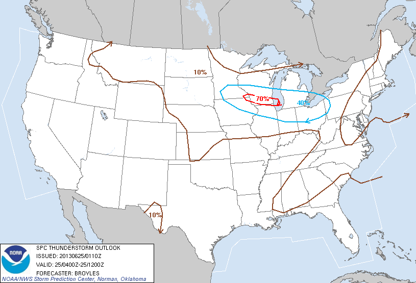
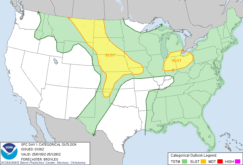
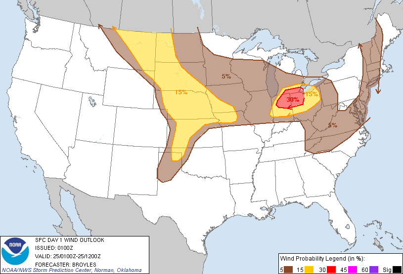
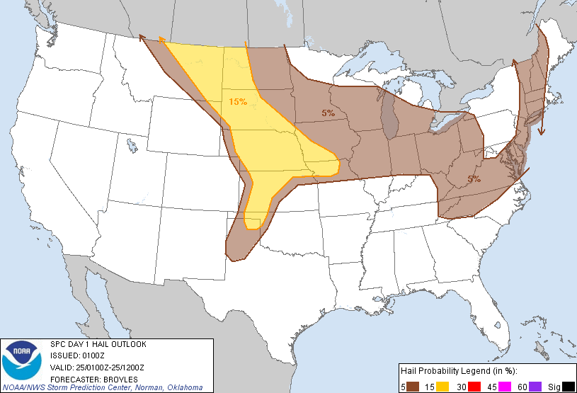
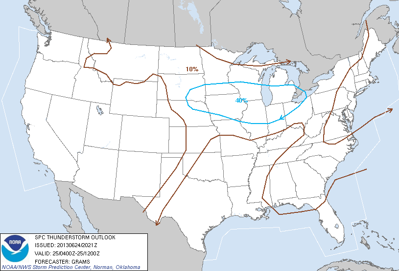
Updated SPC outlooks are here. We are on the border of the 30% probability areas for damaging wind and large hail. The thunderstorm outlook shows our risk dropping after 8pm, though we can still expect some storms across southern MI tonight.

Severe weather outlook via NWS Detroit June 25, 2013

We will continue to see rounds of thunderstorms through Wednesday. (There is continued severe weather potential Wednesday, with risk of damaging winds and large hail, and a slightly increased tornado risk.)

Storms likely to arrive in Ann Arbor 10:45-11pm

KDTX Composite Reflectivity 10:19pm EDT June 24 2013
KDTX Composite Reflectivity 10:19pm EDT June 24 2013. Plus signs indicate lightning.

The storm system that swept across northern Indiana late this afternoon/early this evening is moving our way, and while Ann Arbor is not under a severe thunderstorm watch, some strong storms currently south/southwest of Jackson are headed our way.

These storms have weakened somewhat in the last two hours and are not severe, but are expected to bring 40+mph winds, brief moderate downpours, and occasional lightning, so the usual storm safety advice applies: best to be indoors.

The full special weather statement from NWS Detroit follows:

SPECIAL WEATHER STATEMENT
NATIONAL WEATHER SERVICE DETROIT/PONTIAC MI
1019 PM EDT MON JUN 24 2013

MIZ075-082-250315-
LENAWEE-WASHTENAW-
1019 PM EDT MON JUN 24 2013

...SIGNIFICANT WEATHER ADVISORY...

AT 1015 PM EDT...NATIONAL WEATHER SERVICE DOPPLER RADAR INDICATED
STRONG THUNDERSTORMS ALONG A LINE EXTENDING FROM 24 MILES WEST OF
CHELSEA TO 19 MILES SOUTHWEST OF HUDSON...MOVING EAST AT 45 MPH.

WINDS GREATER THAN 40 MPH...OCCASIONAL CLOUD TO GROUND LIGHTNING...
BRIEF MODERATE DOWNPOURS...ARE POSSIBLE WITH THESE STORMS.

* THUNDERSTORMS WILL BE NEAR...
  ADDISON BY 1025 PM EDT...
  HUDSON AND CEMENT CITY BY 1030 PM EDT...
  CLAYTON BY 1035 PM EDT...
  ONSTED AND MORENCI BY 1040 PM EDT...
  CHELSEA AND MANCHESTER BY 1045 PM EDT...
  CLINTON AND ADRIAN BY 1050 PM EDT...
  DEXTER AND TECUMSEH BY 1055 PM EDT...

GUSTY WINDS MAY CAUSE SMALL OBJECTS SUCH AS TRASH BINS TO BLOW
AROUND. STAY AWAY FROM HIGH OBJECTS OUTDOORS SUCH AS TREES. SEEK
SHELTER IN A STURDY STRUCTURE UNTIL THESE STORMS HAVE PASSED.

$$

MANN

Severe thunderstorm threat continues; watch possible for Ann Arbor in the next hour

Per MD 1212

A severe system responsible for several severe thunderstorm warnings (mostly due to long swaths of damaging winds) in eastern IL and across northern IN is weakening, but continues moving across the upper midwest at 35-45mph. The current severe thunderstorm watch (WW358), in effect until midnight for northern IN and SW/south central MI, may be extended to include SE MI depending on how the storm develops or weakens over the next half hour or so. The system appears to be weakening now, and will continue as temperatures cool; it’s a question of how quickly the system weakens.

NEXRAD Reflectivity Composite via Weather Underground, June 24 2013 9:42pm
Area affected by SPC MD 1212

Additionally, a new thunderstorm outlook issued at 9:10pm EDT, effective through 8am Tuesday, places us squarely in the 40% probability area for thunderstorms.

SPC Thunderstorm Outlook June 24 2013 9pm EDT

The 9pm convective outlook, valid until 8am Tuesday, places us in the “Slight” risk area for severe weather:

SPC Categorical Outlook June 24 2013 9pm EDT

The primary threat from these storms will be damaging wind. We have a 15-30% chance of damaging wind through 8am Tuesday, along with a 5% risk of hail, and a very small tornado risk.

SPC Wind Outlook June 24 2013 9pm EDT
SPC Hail Outlook June 24 2013 9pm EDT
SPC Tornado Outlook June 24 2013 9pm EDT

Thunderstorms just north of Ann Arbor; A2 may be affected this evening (June 24)

KDTX Composite Reflectivity June 24, 2013 7:44pm
KDTX Composite Reflectivity June 24, 2013 7:44pm. Bright yellow box in northern Oakland County is a severe thunderstorm warning; plus signs indicate lightning.

For now, at least, these summer thunderstorms are just north of downtown Ann Arbor, extending north past Flint and west past Lansing. These storms developed relatively quickly late this afternoon, and we can expect development to continue into the evening as the air cools.

A severe thunderstorm watch, effective until midnight EDT, extends into the western third of Washtenaw County; at closest, its border is 10 miles from A2, so I would expect to see some thunderstorms here at some point tonight, some of which may be severe. (Within the severe thunderstorm watch area, which includes the northern half of Indiana and the southwest/south-central portion of Michigan, primary risks are significant damaging winds, large hail, and a few tornadoes.)

Severe Thunderstorm Watch 358

Looking forward, we can expect thunderstorms across the area Tuesday morning. (The SPC puts us in the 40% probability area for thunderstorms from midnight through Tuesday morning.) Some of these storms will be severe, with the primary threats being damaging wind, large hail, and brief heavy downpours.

Thunderstorm outlook June 25 midnight-8am