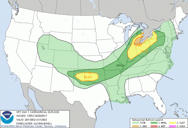
The National Weather Service has determined there is an “enhanced” risk of severe weather in southeastern Michigan this afternoon, primarily from noon to 8pm. (This document outlines what “enhanced risk” means.)
Today, this means that we can expect thunderstorms across the area, some of which will likely be severe. Risks for today’s storms include damaging wind gusts (with fairly high probability) and hail up to 1 inch in diameter. Locally heavy rainfall is possible.
There is a small risk of tornados occurring with any severe storms that develop this afternoon.
Some things to keep in mind:
- Now would be a good time to clear blockages from storm drains in your neighborhood, if you’re home, to prevent your streets from flooding.
- Don’t walk or drive through flooded areas. It takes just 12 inches of fast-moving floodwater to carry away a small car, while 2 feet of rushing water can carry away most vehicles.
- Stay safe from lightning.
Tune into our local emergency broadcasters for timely updates and alerts this afternoon. Finally, it might be useful to review what a severe weather watch vs. a warning means:
Tornado Watch: The Storm Prediction Center (SPC) issues Public Tornado Watches to alert the public, media and emergency managers to organized thunderstorms forecast to produce three or more tornadoes or any tornado which could produce EF2 or greater damage.
Severe Thunderstorm Watch: The Storm Prediction Center (SPC) issues Public Severe Thunderstorm Watches to alert the public, media and emergency managers to organized thunderstorms forecast to produce six and more hail events of 1 inch (quarter) diameter or greater, or damaging winds of 50 knots (58 mph) or greater.
Tornado Warning: … are issued when there is radar indication and/or reliable spotter reports of a tornado.
Severe Thunderstorm Warning: … are issued when there is radar indication and/or reliable spotter reports of hail of 1 inch (quarter) diameter or greater, and/or wind gusts of 50 knots (58 mph) or greater.
